inspiration + perspiration = invention :: T. Edison ::
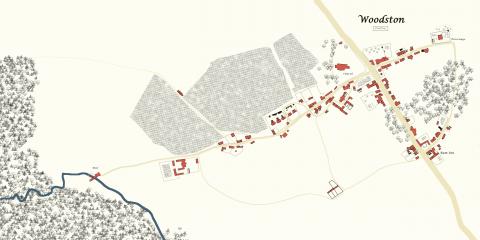
With chapters six and seven releasing on my other online profiles today, the story is about to expand beyond the little parsonage we have largely stayed in up to this point, out into the surrounding countryside. So, for today's bonus blog content, I am sharing my map of the fictional village of Woodston online.
I must confess again that I usually spend far too much time on background material. I have many fictional maps on my hard drive (sometimes of whole planets or solar systems!) Unfortunately, this kind of work usually stops me from ever actually finishing the story. With this book I intentionally resisted the temptation to drown myself in details: I would write almost "blind," and save all but the most minimal research for the editing phase. One I had a completed rough draft, though, I jumped into its geography both to get a better handle on where exactly all my characters were at different points in the narrative, and also because I hope to develop future stories in this setting.
As with houses, Jane Austen does not spare many details for the places her characters inhabit. In Northanger Abbey, she tells us that Woodston is "a large and populous village" about 20 miles from Northanger Abbey, with cottages and chandler shops, and that the parsonage lies "at the further end of the village, and tolerably disengaged from the rest of it ... a new-built substantial stone house, with its semicircular sweep and green gates...." When Catherine and company leave the parsonage house, Austen only adds:
"The influence of fresh objects and fresh air, however, was of great use in dissipating these embarrassing associations; and, having reached the ornamental part of the premises, consisting of a walk round two sides of a meadow, on which Henry’s genius had begun to act about half a year ago, she was sufficiently recovered to think it prettier than any pleasure-ground she had ever been in before, though there was not a shrub in it higher than the green bench in the corner."
This scant description was not quite enough for my story, so it was off to the search engines to look for clues on what an 18th century Gloucestershire village might look like. I am really fortunate to have found a resource called "Know Your Place," a rich guide to high resolution digital maps of western England from different eras. On this website you can clearly search for individual towns and then compare maps to see how they changed and grew over time. Also helpful was the Jane Austen Society of North America's "Hypothetical Map of Highbury."
I settled on the actual village of Yanworth (with some elements borrowed from Painswick) to serve as a base for Woodston: it had a mill, which I knew would be important to my book, and also looked to be the right distance from Bath as Jane Austen inferred. I did "nudge" the countryside a bit here and there for my purposes. Warning: the following image is very big, as I wanted to keep the scale of everything clearly defined.

The parsonage is safely at one end of the village (all the way at the northeastern tip), but not too far away from the church (modeled on the Parish Church of St Mary the Virgin) and its nearby glebe field, which the Tilneys rent rather than farm themselves. I gave Woodston an inn at the southern point leading down the main road, and a good number of houses and buildings, although largely all based on actual structures I found in the various maps I viewed online.
But where, some readers may ask, did the irascible Mr. Wilcox's workhouse come from?
That addition is one completely of my own invention, albeit based on research. The Cotswolds is a region with a long history in the wool trade, dating back to the Middle Ages. By the time the end of the 18th century came, the cloth industry was booming and became a focal point of the early Industrial Revolution.
Mr. Wilcox himself was first developed in a draft for a different story, one I hope to get back to one day, with only a few trace characteristics. In writing Gentlemen of Gloucestershire, I at first only referenced him as the miller's neighbor. While shoring up the plot, I realized I needed to flesh him out further to provide more stressors/stakes for Henry's journey, and so had to figure out who this person actually was and why he lived clear on the edge of town. Gradually his position as an up-and-coming clothier, a man of the burgeoning middle class, took form. If you like (or love to hate) him here, don't worry, I have plans for him to reappear in the future.
If you would like to develop maps or other diagrams yourself, I highly recommend Gimp, an open source alternative to Photoshop. It's been my main photo editor and design tool for years now, and is very easy to get up and running on any machine, including Windows. Especially useful to this project was the Random Density Map GIMP Script I found on the Cartographers' Guild, which allowed me to create randomized tree patterns for the many woods of Woodston.
This map went through many versions as I edited my book, switching up fields and trees and even direction before settling on its current iteration. I hope it provides as much clarity for your enjoyment of the story as it did in helping me polish it.


