inspiration + perspiration = invention :: T. Edison ::
As of today nearly a third of the novel has been released, and the main plot has kicked into gear. To supplement the drama, let's look at another map and more background on the region that gives my book its title, and how this setting impacted the story's development.
When I first began writing last year, I had only one clear image in my mind: Henry and Frederick were trapped in a pit, and Catherine came to rescue them. It was enough to inspire me to get typing, but soon I ran into some important questions that had to be answered. What kind of pit or hole were the two gentlemen stuck in? Why were they there, and why was it there?
Early on I settled on the idea of an abandoned canal as the likeliest reason for this set piece. But I saved my main research into the subject for subsequent editing. Fortunately, it turns out that the end of the 18th century going into the 19th century was known as the "Golden Age" of British canals, and there's plenty of great materials online that helped me visualize what this construction looked like.
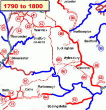
 Map legend at the UK Canal Museum.
I'm particularly indebted to the YouTuber who uploaded a 1993 documentary called "The Story of British Canals," as well as the London Canal Museum's online exhibits. To summarize: the Duke of Bridgewater needed to get coal from his mines in Worsley to Machester, home of early textile manufacturing. The Bridgewater Canal of 1776 was efficient and profitable, and inspired a wave of similar projects and investment/speculation (think the late '90s and the Dot Com bubble).
Once I had this working knowledge to bolster my draft, I needed to get less hazy on the geography. A canal required a river to tap into: where were they in relationship to my two locations, Woodston and Northanger Abbey, which Jane Austen wrote was separated by 20 miles? Time, it would seem, for another map!
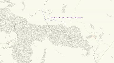
In sketching Woodston it soon became clear I needed a much bigger picture of the area. So I zoomed out to a bird's eye view and patched together several screenshots of Glouchestershire from the imminently helpful Know Your Place website. Other great resources included the "Researching Historic Buildings in the British Isles" website, a RootsWeb Gloucestershire site, and this article on the Thames-Severn Canal.
During this research I was introduced to a term I hadn't known before: this area of England is known as the Cotswolds, comprised of Gloucestershire, Oxfordshire, Warwickshire, Wiltshire, and Worcestershire counties. There are lots of waterways including the Thames, Frome, and Severn. It was a major source of wool from medieval times, with rolling hills and meadows, as well many picturesque villages and farms to this day.
As an aside, while in retrospective it looks planned, the truth is that I originally wrote about missing sheep purely a plot device that sounded appropriate for a country setting, and included a mill in Woodston primarily as an excuse to get my characters closer to the water that must be part of the eventual canal. Only during the editing process did I realize the two must be related, and adapted both Mr. Hayes and Mr. Wilcox to more fully represent the wool and cloth trades.
I realized the more I developed my map that in order for my story to work, Woodston must be closer to Northanger Abbey than might appear to be the case in the original novel. Instead, I had the 20 miles encompass the road one would have to travel by coach to get from one place to the other, and grew a large forest to separate them latitudinally. I was at least partly influenced by how much more walking I've done during the pandemic, especially taking our dog in the woods behind our neighborhood towards the others that border it, and considering how much longer it would take to travel the same distance by car.
This decision brought a new wrinkle, though, as I still had to figure out where the canal actually was; after all, surely the construction would have skirted a thick woodland area? Eventually I settled on it lying just north of the forest, conceived as a transport toward Northleach, a large market town on the main road between Oxford and Cloucester.

The shape of this canal is a bit off and unformed, which I blame on hasty construction and legal skirmishes before it was abandoned. It diverts water away from Northanger Abbey, and I picture a closed sluice gate at its second juncture over the river, which allows for some higher water levels farther down toward Woodston. Northanger Abbey itself didn't get as much detailed attention as the rest of the map, since I could rely more on Austen's description once I arrived there in the narrative; it's more a placeholder than anything else (though that may change if I write future stories set in that location).
It's actually been very interesting to edit this novel while taking longer walks with my family as other activities were curtailed or shut down. There's a government drainage ditch that runs behind the houses on our street into the woods. Regularly traveling these paths has allowed me to see this ditch in all seasons and weather. Sometimes it flows fast and hard, while at others it's nearly empty. One particular day I nearly slipped on the mud, and had a moment of empathy with my characters as I considered how far it would be to fall, and how easily I could get out again if it happened (thankfully, I always have my cell phone with me!)
I hope this information informs you as readers as much as it helped me revise and bring the story into sharper focus. Learning so much about canals got my brain whirring with other ideas for future Tilney stories, which I hope to carve out time to write (eventually).
Have any of you ever been to this region personally or know anything else of interest about it, or experienced any pandemic era explorations of nature? Let me know in the comments.


